Tropical Waves
A tropical wave is a belt of relatively low
pressure that travels across the Atlantic Ocean along the edge of ITCZ (Inter
Tropical Convergence Zone). They are also called Easterly waves, since they
develop in the easterly airflows in the lower troposphere. With it comes
periods of clouds and heavy rains. The lower pressure weather system develops
more frequently in the rainy season, from May to November. Tropical waves have
a lower moisture layer and a drier upper layer. If they lower air is lifted up,
it cools causing condensation and rain. The waves move slowly from east to
west. As they move west, they acquire moisture. They develop in the oceans at
latitudes between 5 degrees Celsius and 30 degrees Celsius. They do not extend across equatorial regions.
Before the tropical wave, air is subsiding
(sinking). The air is being warmed, relative temperature humidity is dropping
and there are dry sunny conditions. During the passing of tropical waves, the
air pressure reduces and the air begins to rise strongly. Cumulonimbus clouds and heavy rainfalls occur during the wave. Wind speed is faster
and gusty along the front of the wave. Behind the tropical waves, there still
is uplift but no so much, resulting in cloudy conditions and light showers. Tropical
waves at times grow in intensity and may eventually develop into storms or
hurricanes.

Cold Fronts
A cold front is the boundary zone in a
depression between dense cold air and the warmer air ahead of it. Occasionally,
winds blow from the cold interior plains of North America in the winter. They
blow out from a centre of high pressure in continental North America between
December and March. For this reason they are called ‘northers’. They are fast moving and associated with a sudden drop
in temperature. The margin between the cold air from North America and the warm
Caribbean air is known as a cold front.
At a cold front, the dense cold air lifts
warm air up. As the cold air travels south, it pushes the warm air upwards leading
to an uplift, cooling and condensation that form clouds. Heavy rain then
results. Cold fronts bring with it cold, wet conditions over many days at
times, that may lead to damaged crops on north facing slopes.
Ahead of the cold front there may be bright
sunshine and light wind approaching from the east. At the cold front, the cold continental air
pushes south, underneath the warm tropical air. There are strong updraughts,
which form thick cumulonimbus clouds. After the cold front, a strong northerly
wind with continental air blows from North America and is warmed as it passes
over the ocean.

Hurricanes
Hurricanes are one of the most natural disasters to the environment. They threaten to impact the region every year during the period of July through November. The official hurricane season is from June to November. In Asia, hurricanes are known as tropical cyclones. As some tropical waves travel over the Atlantic Ocean, they become unstable and develop into a hurricane. This is the initial sequence of a hurricane. A hurricane is a severe or intense revolving tropical storm with winds reaching 119 km per hour or 74 miles per hour or more. It is a very large circular area of low pressure, driven by evaporation from warm seas. Hurricanes develop in the Mid-Atlantic Ocean between latitude 7 degrees north and 20 degrees north. The hurricanes generally move in a north-westerly direction in the Caribbean.
 |
| Structure of a Hurricane |
Conditions
under which hurricanes form
Even though there is not certain cause of a
hurricane, there are certain conditions that cause a hurricane to form.
Hurricanes
generally form over large expanses of warm water. A temperature over 26.5
degrees Celsius is required. This explains why hurricanes occur in the tropics.
The consistent temperature ensures that there is a good supply of moisture for
the hurricane through evaporation, which is the energy for the hurricane.
Warm tropical
waters with a depth of at least 5o meters are required to fuel the hurricane.
As the ocean surface is heated, hot air rises carrying with it water vapour
that condenses into storm clouds brining with them thunderstorm as the
hurricane gather heat and energy through contact with warm waters.
There must be an
updraft of moisture-laden air from the sea to supply or replace the air that is
lost in the troposphere resulting in the formation of thick and extensive cloud
cover.
The rotation of
the earth causes the winds to rotate anti-clockwise in a spiral and upward
motion in the centre of the hurricane. This effect is cause due to the Coriolis
force. Suitable conditions exits between latitudes 5 degrees to 30 degrees
north and south of the Equator.
How
hurricanes develop
Air rises rapidly
over warm oceans where huge quantities of water evaporate very quickly causing
an area of low pressure. As the air
rises, it cools and condenses forming towering cumulus and cumulonimbus clouds.
The air flows from
high pressure to low pressure along with the earth’s rotation causes the
spinning effect and the storm simulates the spinning characteristics like a
Catherine-wheel shape, spinning in an anti-clockwise direction (in the northern
hemisphere).
The initial stage
of the disturbed weather is known as a tropical depression and is given a
number. If the winds intensify then a tropical storm forms and is named. When
the surface wind speeds increases to 75 mph, the storm is officially becomes a
named hurricane.
The prevailing
winds then carry the storm across the ocean by the prevailing winds from the
east to west. As the storm approaches land the supply of warm water stops and
the storm begins to weaken.

Weather conditions associated with Hurricanes
As a hurricane approaches, temperatures and pressure begins to fall. The winds are gentle and from the north-west. Clouds begin to form and a light shower develops. The winds now begin to gust.
During the storm, pressure falls rapidly, wind speeds increases up to 62 miles per hour. Extensive cloud cover by cumulonimbus clouds with thunder and severe rainfall. At the eye of the storm, there is a period of calm. Low pressure and temperatures rises as the sun may appear briefly. As the eye passes, hurricane force winds and torrential rainfall begins. Wind direction now in south-east. The temperature drops again and the pressure begins to rise.
When the storm passes, pressure and temperatures rise. Rainfall decreases to light showers and temperatures increases with the sunny intervals. Wind speeds decreases.
Measuring Hurricanes
Hurricanes are measured using the Saffir-Simpson scale. This scale has units that reflect the wind speed and its effects. The scale ranges from 1 to 5, with 5 being the level the greatest damage is caused and 1 having the least or minimal damage.


Effects
of Hurricanes
Hurricanes can
have several effects on coastal areas as well as inland areas.
Flat coastal areas
are most vulnerable to hurricane damage. Hurricane effects come about in three
main ways, strong winds, heavy rainfall and storm surge.
Strong winds, with wind
speeds in excess of 75 mph (120 km/p) and gust of over 125 mph (200 km/p)
hurricanes can causes extensive damage to buildings, power lines and crops and
trees. Roofs may be blown off, power lines down and trees and crops may be
levelled.
Heavy rainfall, over 200
mm of torrential rainfall may be associated with heavy hurricanes, resulting in
widespread flooding and landslides that may damage infrastructure such as
roads, bridges and buildings. Crops are also destroyed as a result of flooding.
Storm surge, large waves
that a blown onshore by the strong winds. Storm surges often 3-5 meters high
surge over the land in low-lying areas and up river valleys. Hurricane storm surge are the biggest killers
and would flatten everything in its path similar to a tidal waves. Crops will
be destroyed and large quantities of salt water will be left in the areas.
Reducing
Hurricane Hazard
With the aid of
satellites and radar technology, scientists and meteorologist are able to
detect hurricanes and tract their paths. Warnings may then be issued to the areas
at risk.
Persons are made
aware of Hurricanes through, hurricane watch and hurricane warning.
Hurricane Watch, Be
prepared, hurricane conditions are likely in the next 36 hours. Secure and
protect windows and doors, collect water and emergency supplies.
Hurricane Warning, Time to
act, Hurricane conditions are expected in 12-24 hours. Evacuate low-lying areas
or seek shelter.
Intertropical Convergence Zone (ITCZ)
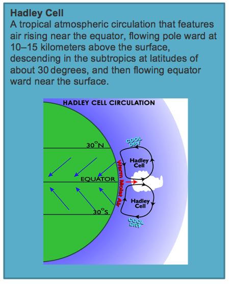 The ITCZ is a broad zone of very unstable
weather that forms at the convergence of winds at two Hadley Cells. At ground level, moist air converges and is
forced to rise. Resulting in rapid cooling, condensation and the formation of
towering cumulonimbus thunderstorm clouds. The ITCZ brings heavy rainfall to
the southern Caribbean countries such as St. Lucia, Trinidad and Barbados. This
weather system is responsible for the unsettled wet weather between the months
of June and November.
The ITCZ is a broad zone of very unstable
weather that forms at the convergence of winds at two Hadley Cells. At ground level, moist air converges and is
forced to rise. Resulting in rapid cooling, condensation and the formation of
towering cumulonimbus thunderstorm clouds. The ITCZ brings heavy rainfall to
the southern Caribbean countries such as St. Lucia, Trinidad and Barbados. This
weather system is responsible for the unsettled wet weather between the months
of June and November.
In summer, in the northern hemisphere, the
sun moves north of the equator, close to the Tropic of Cancer. The ITCZ affects
much of the southern Caribbean then. During winter in the northern hemisphere,
the ITCZ moves further south to lie close to the equator. The weather in the
Caribbean is now affected by a large subtropical belt of high pressure to the
north and generally more settled with sunshine, drier conditions and less rain.

Anticyclones
These are large areas of relatively high
atmospheric pressure that brings with it settled weather conditions. The
weather associated with anticyclones is often with relatively calm winds, clear
skies, high temperatures and low rainfall.
Anticyclones are mainly caused as a result of the global circulation of
air. At about 25—30 degrees north at the edge of the Hadley Cell, air descends.
The sinking air causes a high pressure on the ground which gives rise to dry
conditions experienced in the Caribbean during winter and spring. Hurricanes
can have several effects on coastal areas as well as inland areas.

thanks for the information it was very educating and understandable
ReplyDeleteYou
ReplyDeleteA great
your presentation has been very useful, thank you.
ReplyDelete